Note
Go to the end to download the full example code.
Analyzing traffic convergence#
On this example we show how to use analyze traffic convergence for different segments of the results
Imports#
from pathlib import Path

import geopandas as gpd
import matplotlib.pyplot as plt

from polaris.analyze.path_metrics import PathMetrics
from polaris.analyze.result_kpis import ResultKPIs
from polaris.network.data.data_table_cache import DataTableCache
from polaris.runs.convergence.convergence_iteration import ConvergenceIteration
from polaris.runs.scenario_compression import ScenarioCompression
from polaris.runs.scenario_utils import get_last_iteration
Data Sources#
Open the demand database for analysis
project_dir = Path("/tmp/Bloomington")
iteration_folder = get_last_iteration(project_dir)
supply_db = ScenarioCompression.maybe_extract(Path(iteration_folder) / "Bloomington-Supply.sqlite")

zones = DataTableCache(supply_db).plotting_layer("Zone")
links = DataTableCache(supply_db).plotting_layer("Link")
Data retrieval#
last_iter = ConvergenceIteration.from_dir(iteration_folder)
kpis = ResultKPIs.from_iteration(last_iter)
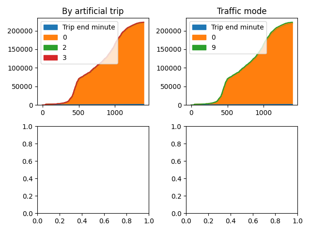
Plotting aggregate results#
def chart_metric(df, metric: str, axis=None):
    df.plot.area(ax=axis)
    axis.set(title=metric)


df = kpis.m_etric_traffic_cumulative_gap()

fig, axis = plt.subplots(2, 2)
all_axis = [axis[0, 0], axis[0, 1], axis[1, 0], axis[1, 1]]
for metric, ax in zip(df.metric.unique(), all_axis):
    df_ = df[df.metric == metric]
    df_ = df_.dropna(axis=1, how="any").sort_values(by="Trip end minute")
    chart_metric(df_, metric, ax)

# Combine all the operations and display
plt.tight_layout()
plt.show()
Totals per zone and link#
pm = PathMetrics(demand_file=last_iter.files.demand_db, h5_file=last_iter.files.result_h5)
traces = pm.data

zlayer = gpd.GeoDataFrame(zones, geometry=gpd.GeoSeries.from_wkt(zones.geo, crs=4326)).reset_index()
llayer = gpd.GeoDataFrame(links, geometry=gpd.GeoSeries.from_wkt(links.geo, crs=4326)).reset_index()
gdf = llayer.sjoin_nearest(zlayer, how="inner")[["link", "zone"]]

gap_per_zone = (
    traces.merge(gdf, left_on="link_id", right_on="link").groupby(["zone"]).sum()[["absolute_gap"]].reset_index()
)
plot_zone_layer = zlayer.merge(gap_per_zone, on="zone").drop(columns=["geo"])

gap_per_link = traces.groupby(["link_id"]).sum()[["absolute_gap"]].reset_index()
plot_link_layer = llayer.merge(gap_per_link, left_on="link", right_on="link_id", how="left").drop(columns=["geo"])
map_center = (zlayer.geometry.centroid.x.mean(), zlayer.geometry.centroid.y.mean())

# Fill in any NaN to avoid kepler GL treating it as a string
plot_link_layer.absolute_gap = plot_link_layer.absolute_gap.fillna(0.0)
plot_zone_layer.absolute_gap = plot_zone_layer.absolute_gap.fillna(0.0)
/home/jamie/git/anl/polarislib/venv/lib/python3.12/site-packages/geopandas/array.py:403: UserWarning: Geometry is in a geographic CRS. Results from 'sjoin_nearest' are likely incorrect. Use 'GeoSeries.to_crs()' to re-project geometries to a projected CRS before this operation.

  warnings.warn(
/home/jamie/git/anl/polarislib/docs/examples/result_analysis/plot_convergence_analysis.py:111: UserWarning: Geometry is in a geographic CRS. Results from 'centroid' are likely incorrect. Use 'GeoSeries.to_crs()' to re-project geometries to a projected CRS before this operation.

  map_center = (zlayer.geometry.centroid.x.mean(), zlayer.geometry.centroid.y.mean())
Cummulative charts#
import seaborn as sns
import matplotlib.pyplot as plt

cumm_links = gap_per_link.sort_values(by=["absolute_gap"], ascending=False).reset_index(drop=True)
cumm_links = cumm_links.assign(cummulative_relative_gap=cumm_links.absolute_gap.cumsum())
cumm_links.cummulative_relative_gap /= cumm_links.cummulative_relative_gap.max()

sns.lineplot(data=cumm_links["cummulative_relative_gap"])
plt.xlabel("link count")
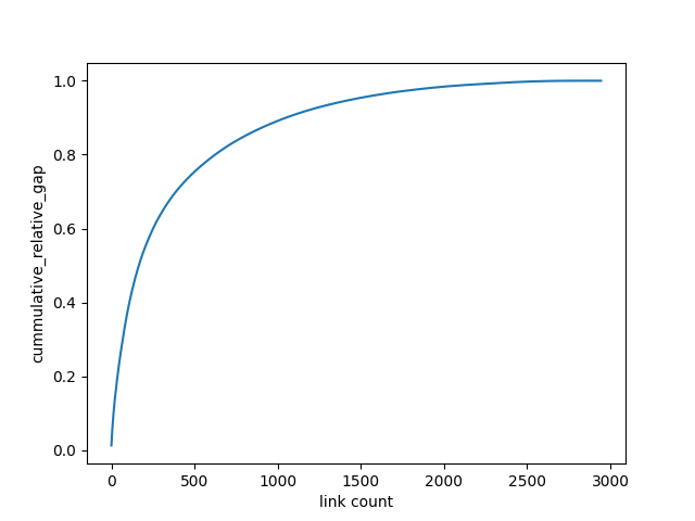
Text(0.5, 23.52222222222222, 'link count')
And map them#
print(
    "REFERENCE: And below we map links and zones according to gaps. The maps should look like this, "
    "but will need formatting"
)
REFERENCE: And below we map links and zones according to gaps. The maps should look like this, but will need formatting
map_zone_config = {
    "version": "v1",
    "config": {
        "visState": {
            "filters": [],
            "layers": [
                {
                    "id": "z0w117",
                    "type": "geojson",
                    "config": {
                        "dataId": "Total gaps",
                        "label": "Total gaps",
                        "color": [34, 63, 154],
                        "highlightColor": [252, 242, 26, 255],
                        "columns": {"geojson": "geometry"},
                        "isVisible": True,
                        "visConfig": {
                            "opacity": 0.8,
                            "strokeOpacity": 0.8,
                            "thickness": 0.1,
                            "strokeColor": [221, 212, 205],
                            "colorRange": {
                                "name": "Uber Viz Diverging 1.5",
                                "type": "diverging",
                                "category": "Uber",
                                "colors": ["#00939C", "#5DBABF", "#BAE1E2", "#F8C0AA", "#DD7755", "#C22E00"],
                            },
                            "strokeColorRange": {
                                "name": "Global Warming",
                                "type": "sequential",
                                "category": "Uber",
                                "colors": ["#5A1846", "#900C3F", "#C70039", "#E3611C", "#F1920E", "#FFC300"],
                            },
                            "radius": 10,
                            "sizeRange": [0, 10],
                            "radiusRange": [0, 50],
                            "heightRange": [0, 500],
                            "elevationScale": 27.8,
                            "enableElevationZoomFactor": True,
                            "stroked": True,
                            "filled": True,
                            "enable3d": True,
                            "wireframe": False,
                        },
                        "hidden": False,
                        "textLabel": [
                            {
                                "field": None,
                                "color": [255, 255, 255],
                                "size": 18,
                                "offset": [0, 0],
                                "anchor": "start",
                                "alignment": "center",
                            }
                        ],
                    },
                    "visualChannels": {
                        "colorField": {"name": "absolute_gap", "type": "integer"},
                        "colorScale": "quantile",
                        "strokeColorField": None,
                        "strokeColorScale": "quantile",
                        "sizeField": None,
                        "sizeScale": "linear",
                        "heightField": {"name": "relative_gap", "type": "real"},
                        "heightScale": "linear",
                        "radiusField": None,
                        "radiusScale": "linear",
                    },
                }
            ],
            "interactionConfig": {
                "tooltip": {
                    "fieldsToShow": {
                        "Total gaps": [
                            {"name": "zone", "format": None},
                            {"name": "absolute_gap", "format": None},
                            {"name": "relative_gap", "format": ".1%"},
                        ]
                    },
                    "compareMode": False,
                    "compareType": "absolute",
                    "enabled": True,
                },
                "brush": {"size": 0.5, "enabled": False},
                "geocoder": {"enabled": False},
                "coordinate": {"enabled": False},
            },
            "layerBlending": "normal",
            "splitMaps": [],
            "animationConfig": {"currentTime": None, "speed": 1},
        },
        "mapState": {
            "bearing": 24,
            "dragRotate": True,
            "latitude": map_center[1],
            "longitude": map_center[0],
            "pitch": 50,
            "zoom": 9.096117833833905,
            "isSplit": False,
        },
        "mapStyle": {
            "styleType": "muted",
            "topLayerGroups": {},
            "visibleLayerGroups": {
                "label": True,
                "road": False,
                "border": False,
                "building": True,
                "water": True,
                "land": True,
                "3d building": False,
            },
            "threeDBuildingColor": [224.4071295378559, 224.4071295378559, 224.4071295378559],
            "mapStyles": {},
        },
    },
}
from keplergl import KeplerGl

map1 = KeplerGl(height=900, data={"Total gaps": plot_zone_layer}, config=map_zone_config)

map1
User Guide: https://docs.kepler.gl/docs/keplergl-jupyter

KeplerGl(config={'version': 'v1', 'config': {'visState': {'filters': [], 'layers': [{'id': 'z0w117', 'type': 'geojson', 'config': {'dataId': 'Total gaps', 'label': 'Total gaps', 'color': [34, 63, 154], 'highlightColor': [252, 242, 26, 255], 'columns': {'geojson': 'geometry'}, 'isVisible': True, 'visConfig': {'opacity': 0.8, 'strokeOpacity': 0.8, 'thickness': 0.1, 'strokeColor': [221, 212, 205], 'colorRange': {'name': 'Uber Viz Diverging 1.5', 'type': 'diverging', 'category': 'Uber', 'colors': ['#00939C', '#5DBABF', '#BAE1E2', '#F8C0AA', '#DD7755', '#C22E00']}, 'strokeColorRange': {'name': 'Global Warming', 'type': 'sequential', 'category': 'Uber', 'colors': ['#5A1846', '#900C3F', '#C70039', '#E3611C', '#F1920E', '#FFC300']}, 'radius': 10, 'sizeRange': [0, 10], 'radiusRange': [0, 50], 'heightRange': [0, 500], 'elevationScale': 27.8, 'enableElevationZoomFactor': True, 'stroked': True, 'filled': True, 'enable3d': True, 'wireframe': False}, 'hidden': False, 'textLabel': [{'field': None, 'color': [255, 255, 255], 'size': 18, 'offset': [0, 0], 'anchor': 'start', 'alignment': 'center'}]}, 'visualChannels': {'colorField': {'name': 'absolute_gap', 'type': 'integer'}, 'colorScale': 'quantile', 'strokeColorField': None, 'strokeColorScale': 'quantile', 'sizeField': None, 'sizeScale': 'linear', 'heightField': {'name': 'relative_gap', 'type': 'real'}, 'heightScale': 'linear', 'radiusField': None, 'radiusScale': 'linear'}}], 'interactionConfig': {'tooltip': {'fieldsToShow': {'Total gaps': [{'name': 'zone', 'format': None}, {'name': 'absolute_gap', 'format': None}, {'name': 'relative_gap', 'format': '.1%'}]}, 'compareMode': False, 'compareType': 'absolute', 'enabled': True}, 'brush': {'size': 0.5, 'enabled': False}, 'geocoder': {'enabled': False}, 'coordinate': {'enabled': False}}, 'layerBlending': 'normal', 'splitMaps': [], 'animationConfig': {'currentTime': None, 'speed': 1}}, 'mapState': {'bearing': 24, 'dragRotate': True, 'latitude': 40.49083374959828, 'longitude': -88.97889575473327, 'pitch': 50, 'zoom': 9.096117833833905, 'isSplit': False}, 'mapStyle': {'styleType': 'muted', 'topLayerGroups': {}, 'visibleLayerGroups': {'label': True, 'road': False, 'border': False, 'building': True, 'water': True, 'land': True, '3d building': False}, 'threeDBuildingColor': [224.4071295378559, 224.4071295378559, 224.4071295378559], 'mapStyles': {}}}}, data={'Total gaps':      zone              x  ...                                           geometry  absolute_gap
0      11  338069.883058  ...  MULTIPOLYGON (((-88.90316 40.56121, -88.90311 ...       507.184
1      22  330707.164759  ...  MULTIPOLYGON (((-88.99536 40.539, -88.99605 40...       118.618
2      25  335148.199834  ...  MULTIPOLYGON (((-88.94809 40.54702, -88.94557 ...       122.993
3      27  336338.870581  ...  MULTIPOLYGON (((-88.92499 40.54679, -88.92497 ...       458.232
4      28  335236.733507  ...  MULTIPOLYGON (((-88.94796 40.53218, -88.94844 ...       217.770
..    ...            ...  ...                                                ...           ...
179   287  333970.675141  ...  MULTIPOLYGON (((-88.9639 40.45445, -88.96297 4...      2639.468
180   292  331511.223925  ...  MULTIPOLYGON (((-88.98178 40.46666, -88.98176 ...      1995.777
181   293  330481.680006  ...  MULTIPOLYGON (((-89.00495 40.48432, -89.00542 ...      2744.297
182   296  328692.674180  ...  MULTIPOLYGON (((-89.02329 40.47078, -89.02377 ...       548.725
183   297  328861.007192  ...  MULTIPOLYGON (((-89.0225 40.47905, -89.02391 4...       981.063

[184 rows x 32 columns]}, height=900)
link_config = {
    "version": "v1",
    "config": {
        "visState": {
            "filters": [],
            "layers": [
                {
                    "id": "xiykhj",
                    "type": "geojson",
                    "config": {
                        "dataId": "Total gaps",
                        "label": "Total gaps",
                        "color": [248, 149, 112],
                        "highlightColor": [252, 242, 26, 255],
                        "columns": {"geojson": "geometry"},
                        "isVisible": True,
                        "visConfig": {
                            "opacity": 0.8,
                            "strokeOpacity": 1,
                            "thickness": 0.5,
                            "strokeColor": None,
                            "colorRange": {
                                "name": "Global Warming",
                                "type": "sequential",
                                "category": "Uber",
                                "colors": ["#5A1846", "#900C3F", "#C70039", "#E3611C", "#F1920E", "#FFC300"],
                            },
                            "strokeColorRange": {
                                "name": "Uber Viz Diverging 3.5",
                                "type": "diverging",
                                "category": "Uber",
                                "colors": [
                                    "#00939C",
                                    "#2FA7AE",
                                    "#5DBABF",
                                    "#8CCED1",
                                    "#BAE1E2",
                                    "#F8C0AA",
                                    "#EB9C80",
                                    "#DD7755",
                                    "#D0532B",
                                    "#C22E00",
                                ],
                            },
                            "radius": 10,
                            "sizeRange": [0.2, 20],
                            "radiusRange": [0, 50],
                            "heightRange": [0, 500],
                            "elevationScale": 5,
                            "enableElevationZoomFactor": True,
                            "stroked": True,
                            "filled": False,
                            "enable3d": False,
                            "wireframe": False,
                        },
                        "hidden": False,
                        "textLabel": [
                            {
                                "field": None,
                                "color": [255, 255, 255],
                                "size": 18,
                                "offset": [0, 0],
                                "anchor": "start",
                                "alignment": "center",
                            }
                        ],
                    },
                    "visualChannels": {
                        "colorField": None,
                        "colorScale": "quantile",
                        "strokeColorField": {"name": "absolute_gap", "type": "integer"},
                        "strokeColorScale": "quantile",
                        "sizeField": {"name": "absolute_gap", "type": "integer"},
                        "sizeScale": "linear",
                        "heightField": None,
                        "heightScale": "linear",
                        "radiusField": None,
                        "radiusScale": "linear",
                    },
                }
            ],
            "interactionConfig": {
                "tooltip": {
                    "fieldsToShow": {
                        "Total gaps": [{"name": "link", "format": None}, {"name": "absolute_gap", "format": None}]
                    },
                    "compareMode": False,
                    "compareType": "absolute",
                    "enabled": True,
                },
                "brush": {"size": 0.5, "enabled": False},
                "geocoder": {"enabled": False},
                "coordinate": {"enabled": False},
            },
            "layerBlending": "normal",
            "splitMaps": [],
            "animationConfig": {"currentTime": None, "speed": 1},
        },
        "mapState": {
            "bearing": 0,
            "dragRotate": False,
            "latitude": map_center[1],
            "longitude": map_center[0],
            "pitch": 0,
            "zoom": 8.42575627208353,
            "isSplit": False,
        },
        "mapStyle": {
            "styleType": "muted",
            "topLayerGroups": {},
            "visibleLayerGroups": {
                "label": False,
                "road": False,
                "border": False,
                "building": True,
                "water": True,
                "land": True,
                "3d building": False,
            },
            "threeDBuildingColor": [224.4071295378559, 224.4071295378559, 224.4071295378559],
            "mapStyles": {},
        },
    },
}
from keplergl import KeplerGl

map2 = KeplerGl(height=900, data={"Total gaps": plot_link_layer}, config=link_config)

map2
User Guide: https://docs.kepler.gl/docs/keplergl-jupyter

KeplerGl(config={'version': 'v1', 'config': {'visState': {'filters': [], 'layers': [{'id': 'xiykhj', 'type': 'geojson', 'config': {'dataId': 'Total gaps', 'label': 'Total gaps', 'color': [248, 149, 112], 'highlightColor': [252, 242, 26, 255], 'columns': {'geojson': 'geometry'}, 'isVisible': True, 'visConfig': {'opacity': 0.8, 'strokeOpacity': 1, 'thickness': 0.5, 'strokeColor': None, 'colorRange': {'name': 'Global Warming', 'type': 'sequential', 'category': 'Uber', 'colors': ['#5A1846', '#900C3F', '#C70039', '#E3611C', '#F1920E', '#FFC300']}, 'strokeColorRange': {'name': 'Uber Viz Diverging 3.5', 'type': 'diverging', 'category': 'Uber', 'colors': ['#00939C', '#2FA7AE', '#5DBABF', '#8CCED1', '#BAE1E2', '#F8C0AA', '#EB9C80', '#DD7755', '#D0532B', '#C22E00']}, 'radius': 10, 'sizeRange': [0.2, 20], 'radiusRange': [0, 50], 'heightRange': [0, 500], 'elevationScale': 5, 'enableElevationZoomFactor': True, 'stroked': True, 'filled': False, 'enable3d': False, 'wireframe': False}, 'hidden': False, 'textLabel': [{'field': None, 'color': [255, 255, 255], 'size': 18, 'offset': [0, 0], 'anchor': 'start', 'alignment': 'center'}]}, 'visualChannels': {'colorField': None, 'colorScale': 'quantile', 'strokeColorField': {'name': 'absolute_gap', 'type': 'integer'}, 'strokeColorScale': 'quantile', 'sizeField': {'name': 'absolute_gap', 'type': 'integer'}, 'sizeScale': 'linear', 'heightField': None, 'heightScale': 'linear', 'radiusField': None, 'radiusScale': 'linear'}}], 'interactionConfig': {'tooltip': {'fieldsToShow': {'Total gaps': [{'name': 'link', 'format': None}, {'name': 'absolute_gap', 'format': None}]}, 'compareMode': False, 'compareType': 'absolute', 'enabled': True}, 'brush': {'size': 0.5, 'enabled': False}, 'geocoder': {'enabled': False}, 'coordinate': {'enabled': False}}, 'layerBlending': 'normal', 'splitMaps': [], 'animationConfig': {'currentTime': None, 'speed': 1}}, 'mapState': {'bearing': 0, 'dragRotate': False, 'latitude': 40.49083374959828, 'longitude': -88.97889575473327, 'pitch': 0, 'zoom': 8.42575627208353, 'isSplit': False}, 'mapStyle': {'styleType': 'muted', 'topLayerGroups': {}, 'visibleLayerGroups': {'label': False, 'road': False, 'border': False, 'building': True, 'water': True, 'land': True, '3d building': False}, 'threeDBuildingColor': [224.4071295378559, 224.4071295378559, 224.4071295378559], 'mapStyles': {}}}}, data={'Total gaps':       link                 name  node_a  ...                                           geometry  link_id absolute_gap
0        4       Landmark Drive       6  ...  LINESTRING (-88.95543 40.51243, -88.95539 40.5...      4.0        6.000
1        6       Landmark Drive       7  ...  LINESTRING (-88.95539 40.51136, -88.95538 40.5...      6.0        6.000
2       10       Mecherle Drive      12  ...  LINESTRING (-88.9607 40.49187, -88.96029 40.49...     10.0        7.000
3       11       Mecherle Drive      14  ...  LINESTRING (-88.96336 40.49358, -88.96151 40.4...      NaN        0.000
4       12       Mecherle Drive      13  ...  LINESTRING (-88.96029 40.49126, -88.96007 40.4...      NaN        0.000
...    ...                  ...     ...  ...                                                ...      ...          ...
4522  5993  Brigham School Road    3742  ...  LINESTRING (-89.00205 40.44163, -89.00538 40.4...   5993.0        5.584
4523  5994    South Main Street    3151  ...  LINESTRING (-88.99098 40.4416, -88.9912 40.44586)   5994.0       15.104
4524  5995    South Main Street    3743  ...  LINESTRING (-88.9912 40.44586, -88.99125 40.44...   5995.0        7.000
4525  5996    South Main Street    3318  ...  LINESTRING (-88.9921 40.45005, -88.99242 40.45...   5996.0       12.051
4526  5997    South Main Street    3744  ...  LINESTRING (-88.99246 40.45429, -88.99247 40.4...   5997.0       26.483

[4527 rows x 23 columns]}, height=900)
Total running time of the script: (0 minutes 1.735 seconds)